Walk into almost any school classroom or kids' playroom, and you're bound to see a familiar sight: a round, plastic globe gathering dust on a bookshelf.
For decades, the physical globe has been the gold standard for teaching children about our planet. But as technology and educational psychology evolve, a shift is happening, supported by National Geographic's spatial learning guides that highlight how spatial thinking boosts long-term problem-solving abilities. Busy parents and teachers are realizing that traditional spinning globes have significant limitations.
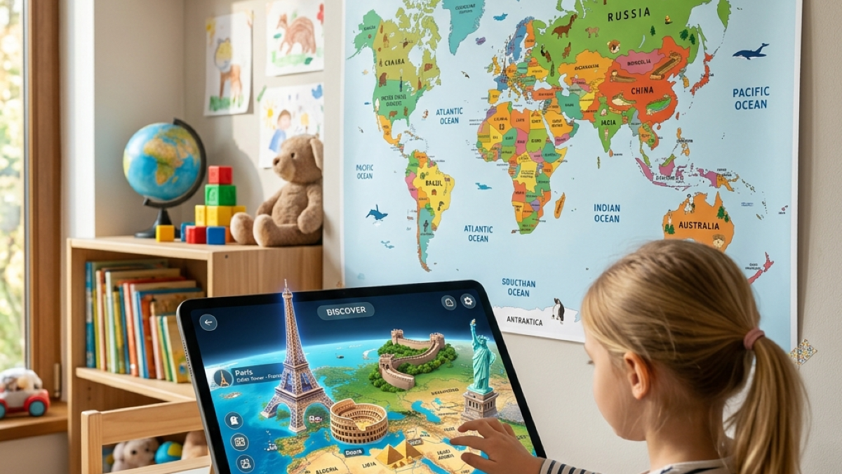
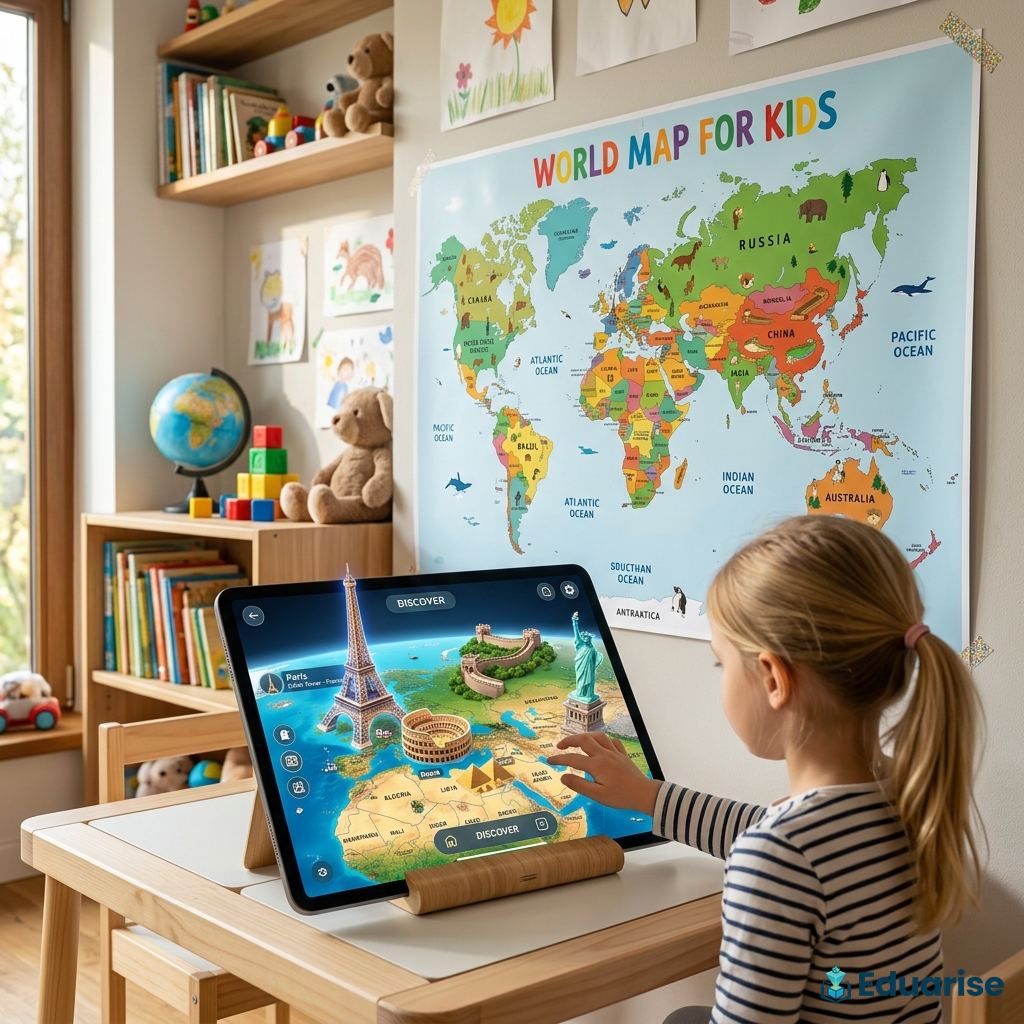
Enter the era of printable AR maps.
By combining simple, printable paper designs with modern augmented reality (AR) technology, printable AR maps are completely changing how children interact with geography. Here is why flat, printable AR maps are the future of interactive learning—and why they are a much better alternative to bulky, expensive smart globes.
1. The Clutter Cure: Zero Shelf Space Required
Let's be completely honest: playrooms get cluttered fast. Traditional globes are bulky, hollow plastic spheres that take up significant desk or shelf space. They cannot be folded, they cannot be stacked, and they are notorious dust magnets.
Printable AR maps solve the storage crisis completely.
Because the map is printed on flat paper, it takes up zero physical space when not in use. You can easily:
- Tape it flat to a playroom wall or closet door as a permanent, interactive poster.
- Fold it up and tuck it into a binder, portfolio, or desk drawer.
- Slip it inside a homeschooling workbook as a permanent unit study reference.
When your child is ready to play, they simply scan the flat paper with their tablet or phone, and the map instantly expands into a rich, three-dimensional learning hub. You get the exact same 3D visual benefits of a spherical globe without the physical footprint.
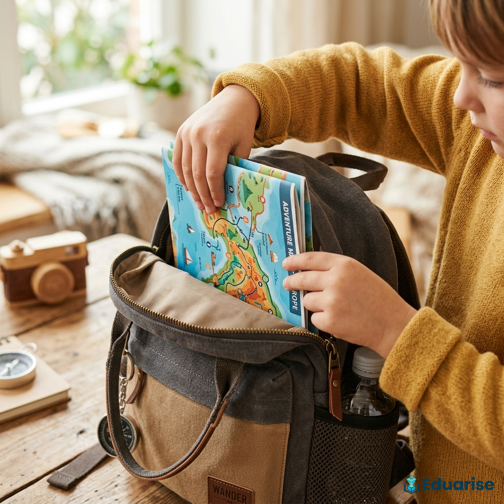
2. Unbeatable Portability for Road Trips and Flights
Have you ever tried packing a traditional plastic globe into a child's backpack for a family vacation? It's practically impossible.
For active families, keeping kids productively engaged during long travel days is a constant struggle. Bringing interactive toys on the go usually means carrying heavy plastic gear, charging cords, and accessories.
Printable AR maps are the ultimate travel hack.
You can print your map, roll it up or fold it flat, and slide it into a backpack pocket. Whether you're on a 6-hour flight, sitting in the back of an SUV on a road trip, or waiting for food to arrive at a restaurant, you can simply pull out the paper map, open the app on your phone, and let your kids explore the world in 3D. For parent-approved recommendations across all styles of map play, check out the best geography toys for 5-year-olds that keep preschoolers deeply engaged.
3. Financial Accessibility: Premium Tech on a Budget
The biggest barrier to interactive STEM toys is cost. Bulky electronic smart globes (like those from PlayShifu or LeapFrog) routinely retail between $50 and $100.
For homeschooling families on a budget or teachers trying to supply resources for an entire classroom, spending hundreds of dollars on plastic hardware is simply not feasible.
Printable AR maps democratize early education.
For example, the Eduarise AR World Map is a digital file that costs just $9.99 (on sale from $24.99). (If you are currently shopping for alternative brands, don't miss our breakdown of the top PlayShifu alternatives that offer outstanding educational value without the clutter). It requires zero custom hardware or expensive plastic manufacturing. You simply pay for the digital file once, print it on standard paper, and download the free app.
Additionally, if the printed paper gets ripped, stained, or drawn on with crayons, you don't have to throw away a $60 toy. You simply click "print" again and have a brand-new, pristine interactive map ready to go in under 60 seconds.
4. Scalability for Classrooms and Homeschool Co-Ops
For educators, teaching geography to a room of 20 kids with a single physical globe is a recipe for distraction. Only one child can spin and interact with the globe at a time, while the rest of the classroom loses focus.
Because printable maps are digital assets, they offer infinite scalability. A teacher can buy a single digital license and print 25 copies—one for every student in the room.
Each student can tape their map directly into their individual geography notebooks. During lesson time, students can work at their own desks, using school tablets to scan their personal maps to study animal migration, landmarks, and flags independently. It turns passive listening into active, individualized learning.
5. Easy Content Updates (No Outdated Maps)
Geopolitical borders, capital names, and scientific discoveries change. When you buy a physical plastic globe, the map printed on it is frozen in time. If a country changes its name or a border shifts, your expensive globe instantly becomes outdated.
With printable AR maps, the maps are completely dynamic. Because the core content is driven by the mobile app, the interactive landmarks, animal facts, and quizzes are updated regularly in the cloud. If an update to the physical map is ever needed, the manufacturer can simply send an updated PDF file to your email, allowing you to print the latest version instantly.
Summary: Bulky Globes vs. Printable AR Maps
Let's look at how these two approaches compare head-to-head:
Feature Bulky Plastic Globes Printable AR Maps (Eduarise) Average Cost | $50 - $100 | $9.99
Storage Space | Large physical footprint | Folds flat, zero clutter
Portability | Hard to transport | Extremely travel-friendly
Classroom Use | One child at a time | Infinite prints for every student
Durability | Plastic breaks/cracks | If it rips, just print it again!
The Verdict: The Future is Flat (and Interactive)
Traditional globes will always have a nostalgic place in educational history. But for modern parents and teachers looking for affordable, clutter-free, and travel-ready solutions, printable AR maps are the clear future.
They provide the exact same rich, engaging, 3D interactive learning experience as high-end smart globes—at a fraction of the cost, with zero clutter.
Ready to upgrade your child's geography lessons?
Skip the bulky plastic and the high price tag. Download the interactive map and start exploring the world in 3D today!
👉 Download and Print the Eduarise AR World Map Instantly Today!